Matter and Weather
Earth and the Biosphere
(including Solar System, Forces and Motion)
Mrs. Honan
_______________________________________________________________________
____________________________________________________________________
____________________________________________________________________
Matter and Weather
WEATHER DISCUSSION and Forecasting: Links to map/satellite image at bottom of page.
Introduction - Layers of the Atmosphere (image and video)
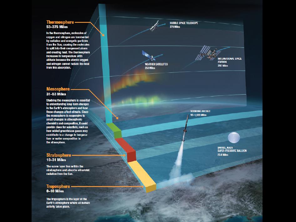
Layers of the Atmosphere image source: NASA
Required Student Simulations and Vocabulary Review:
7th - all below! DAILY WEATHER DISCUSSION AND FORECASTING:
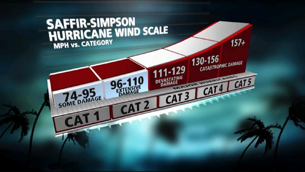
Source: http://www.weather.com/outlook/weather-news/hurricanes/articles/hurricane-saffir-simpson-wind-scale_2010-05-24
|
General Forecasting Info: Monitoring the map for incoming fronts associated with low (red L) pressure systems (from the west, pushed by the westerlies, our prevailing winds) is almost the sum total of our weather picture in NC - the other piece is strong tropical depressions originating off western Africa in the Atlantic, gaining energy from warm oceans, spring to fall, which, of course, is our tropical storm/hurricane source. Cold fronts (blue triangle lines on map) push air up dramatically, causing cooling and therefore cloud formation and storms; warm fronts (red semi-circles) are less strong, riding gently up over colder air and causing gentler, sustained precipitation. Occluded fronts (overlapping red and blue lines with symbols facing opposite directions) and stationary fronts (opposing red and blue lines, symbols facing same direction) both produce unstable air at the surface, with air rising, clouds forming and storms possible/likely.
Students should play with the Fronts button above until the types of fronts are solid in their minds. General Tropical Forecast Info: These three satellite images show tropical depression, storm and hurricane/typhoon development in the Atlantic, Eastern and Western Pacific Oceans. Warm ocean water heats the air, allowing lots of evaporation and heated rising air (and causing low pressure centers), creating the conditions which can develop into brutal tropical storms/hurricanes. |
WEATHER FORECASTING:
Local/Regional: Using the current weather map button link to the left and the NWS button for Concord airport (KJQF) data, make predictions of change or persistence (conditions staying the same) based on what Low pressure systems/fronts are near our region/on their way to our region. Tropical Report: View the three maps below and the video at the top (click Tropical Report button) See the Saffir-Simpson wind scale graphic on the left for hurricane/typhoon strength and damage potential. Remember, hurricane and typhoon are the same storm, but in different parts of the world. ________________________________________________ ______________________________________________________________________ |
